A plane figure with a number of sides. In a regular polygon all the sides and internal angles are equal. For such a polygon with n sides, the interior angle is (180 − 360/n) degrees and the sum of the interior angles is (180n − 360) degrees.
A plane figure bounded by some number of straight sides. This definition would include polygons like the one shown, but often
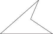
A concave (non-convex) polygon
figures of this sort are intended to be excluded and it is implicitly assumed that a polygon is to be convex. Thus a convex polygon is a plane figure consisting of a finite region bounded by some finite number of lines, in the sense that the region lies entirely on one side of each line. The exterior angles of the polygon shown below are those marked,
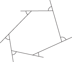
Exterior angles of a convex polygon
and the sum of the exterior angles is always equal to 360°. The sum of the interior angles of an n-sided convex polygon equals 2n−4 right angles. In a regular convex polygon, all the sides have equal length and the interior angles have equal size; and the vertices are concylic.
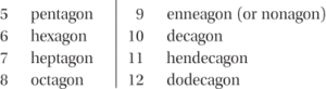
Table of polygons’ names
1 In geomorphology a sand wedge polygon is a micro-relief landform, 7–14 m in diameter, ‘devoid of vegetation and…outlined by textural changes in the soil’ (Péwé (1959) Am. J. Sci. 257). Ice-wedge polygons are formed after a temperature drop so extreme that ‘the ground contracts and cracks, forming a narrow void. During the winter, snow blowing across the tundra surface fills in the crack and freezes to form a thin ice vein. The following spring the ice vein thaws, but it refreezes the following winter and the ground preferentially cracks again along the same ice vein. New snow blows into the crack and freezes, gradually “wedging” the ground open’ (Morgan (1972) Canad. J. Earth Scis 9, 6).
2 In GIS, a closed area bounded by a connected sequence of paired x and y coordinates, the first and last coordinate pairs being the same, and all other pairs being unique. More commonly known as an area.
- glyceride
- glycerides
- glycerine
- glycerol
- glycerophospholipid
- glycerophospholipids
- glycine
- glycobiology
- glycocalyx
- glycogen
- glycogenesis
- glycogenolysis
- glycol
- glycolate pathway
- glycolic acid
- glycolipid
- glycolysis
- glycomics
- glycoprotein
- glycosaminoglycan
- glycoside
- glycosidic bond
- glycosidic link
- glycosuria
- glycosylation