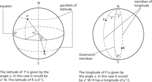
1. (in geography) Imaginary lines on the earth’s surface, enabling any point to be defined in terms of two angles subtended at its centre. Parallels of latitude are circles drawn round the earth parallel to the equator; their diameters diminish as they approach the poles. These parallels are specified by the angle subtended at the centre of the earth by the arc formed between a point on the parallel and the equator. All points on the equator therefore have a latitude of 0°, while the north pole has a latitude of 90°N and the south pole of 90°S. Parallels of latitude 1° apart are separated on the earth’s surface by about 100 km.
Meridians of longitude are half great circles passing through both poles; they cross parallels of latitude at right angles. In 1884 the meridian through Greenwich, near London, was selected as the prime meridian and designated as 0°. Other meridians are defined by the angle between the plane of the meridian and the plane of the prime meridian specifying whether it is E or W of the prime meridian. At the equator meridians 1° apart are separated by about 112 km.
2. (in astronomy) The celestial latitude of a star, or other celestial body, is its angular distance north (taken as positive) or south (taken as negative) of the ecliptic measured along the great circle through the body and the poles of the ecliptic. The celestial longitude is the angular distance from the vernal equinox measured eastwards along the ecliptic to the intersection of the body’s circle of longitude; it is measured in the same direction as the sun’s apparent annual motion.
Latitude and longitude.
- blockbusting
- blockchain
- block cipher
- block code
- block compaction
- block copolymer
- block design
- block diagonal matrix
- block diagram
- blocked buyer list
- blocked impedance
- blocked process
- blockette
- block field
- blockfield
- block flow diagram
- block glide
- blocking
- Margaret, St (1046–93)
- margaric acid
- margarine
- margarite
- margin
- marginal basin
- marginal benefit