Concentrated, high-speed air flow, generally in a broadly westerly (i.e. west to east) direction. The principal global jets are the polar front and the subtropical jets, at heights of about 10–12 and 12–15 km respectively, and the polar-night or winter jet stream in the upper stratosphere or mesosphere at about 50–80 km. The intensity of the jets in narrow bands (the maximum velocity is commonly about 50–100 m/s, but greater speeds are sometimes observed) results from a large poleward increase in pressure gradient with altitude. This is a product of the pole–equator temperature gradient in the air beneath the jet, i.e. it is a thermal wind. As pressure decreases more rapidly with height the lower the temperature, so pressure in the colder, polar air masses decreases more rapidly with height than over the regions with warmer air masses. Above the jet, wind speed diminishes as the pressure gradient declines with increasing height, owing to the effects of a different heating pattern in the stratosphere. See also polar-front jet stream; subtropical jet stream.
‘A sinuous, relatively narrow ribbon of air that encircles the globe at an altitude of around 11 km, sometimes reaching speeds of 400 kph. They form where there is a substantial variation of air temperature within a relatively short geographical distance’ (Meteogroup, 26 Nov. 2006). The westerly jet streams (J) in the Northern Hemisphere lie where significant breaks occur in the tropopause.
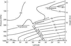
The polar-front jet stream is a frontal wind, not necessarily continuous, blowing west to east just below the tropopause, parallel to the surface fronts and moving with them, and draining the air rising from the fronts. It is strongest at the 200–300 mb level, and swings between latitudes 40 and 60 °N; speed and location vary from day to day with the Rossby waves. This jet marks the polar front, and has important effects on convergence and divergence in the upper air. Divergence is more frequent in the downstream, poleward sector of the jet core, and is associated with extratropical cyclone development. At the ‘jet entrance’, the pressure gradient steepens, and the wind becomes super-geostrophic, leading to high-level convergence. The polar-front jets often ‘steer’ the movement of major low-level air masses.
A strong polar-front jet is associated with rapidly moving depressions (Galvin (2006) Weather 15, 11), but the jet stream and its accompanying depressions in the surface can be diverted by anticyclones. This jet splits into the polar front jet and subtropical jet, which develop each year in March through to early Southern Hemispheric spring (Bertler et al. (2006) Advances Geoscis 6, 83386).
The westerly subtropical jet is at the poleward limit of the Hadley cell, around 30°N and S; the northern subtropical jet is strongest at the 200 mb level, and above the Indian subcontinent. This is one of the most powerful wind systems on Earth, at times reaching speeds of 135 m s−1, and it follows a more fixed pattern than the polar-front jet. It results from the poleward drift of air in the Hadley circulation and the conservation of angular momentum. Chen and Yen (1986) Mon. Wea. Rev. 114, 255032570, are among many to link this jet with the South Asian summer monsoon.
The easterly tropical jet develops during the summer months at 15°N, and is strongest at the time of the summer monsoon. The stratospheric subpolar jet stream blows at a height of 30 000 m, being westerly in winter and easterly in summer.
Jet stream. Identified by J on the chart
- sliding window
- Sliding Window Protocol
- sliding–toppling condition
- slime
- slime mould
- Slim, William Joseph, 1st Viscount (1891–1970)
- sling psychrometer
- slingram method
- slingshot
- slip
- slipface
- Slipher, Earl Carl (1883–1964)
- Slipher, Vesto Melvin
- Slipher, Vesto Melvin (1875–1969)
- slip-off slope
- slippage test
- slippery slope
- slip-plate
- slip ratio
- SLN
- Sloan Digital Sky Survey
- SLOC
- sloc
- slope
- slope angle