European Space Agency Earth Explorer Mission satellite using a microwave radiometer to capture images of ‘brightness temperature’, which correspond to microwave radiation emitted from Earth’s surface, which can be related to soil moisture and ocean salinity which can be used to gain information on soil moisture at a resolution of 50 km per pixel. Launched on 2 November 2009, the satellite is designed to help better weather and extreme-event forecasting and seasonal-climate forecasting. SMOS is helping to revolutionize the way satellite data are used for practical purposes, such as farming; for instance, SMOS measurements were used to create maps showing areas with favourable locust-swarming conditions about 70 days ahead of the November 2016 outbreak in Mauritania.
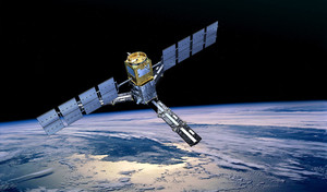
ESA 's Soil Moisture Ocean Salinity satellite in orbit. The satellite has clocked up more than 1 billion kilometres orbiting Earth to improve our understanding of our planet's water cycle.
Credit: ESA/AOES medialabs
- MCMC
- McMillan, Edwin Mattison
- McMillan–Mayer theory
- McMonagle, Donald Ray (1952– )
- McNair, Ronald E (1950–86)
- McNaught, Comet
- McNemar, Quinn (1900–86)
- McNemar test
- M-commerce
- MCPC
- MCSs
- MCT
- McTaggart, John McTaggart Ellis (1866–1925)
- MD2
- MD5
- tweet
- tweeter
- Twenhofel, William Henry (1875–1957)
- Twentieth Congress (February 1956)
- Twenty‐One Demands
- twiddle
- twilight
- twin axis
- twin cable
- twin-earth