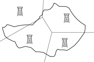
See Dirichlet tessellation.
A subdivision of a drainage basin, containing a rain gauge. Polygons are constructed by first siting the rain gauges, plotting them on a base map, and connecting the sites by straight lines. The lines are bisected with perpendiculars, which meet to form the polygons. The areas of the polygons are calculated and expressed as fractions of the total area. Each fraction is multiplied by the precipitation recorded by its rain gauge. The sum of these calculations represents total precipitation over the catchment area. For an account, see Yoo et al. (2007) J. Hydrol. 335, 3–4.

Thiessen polygon