Diagram showing the vertical variation in properties of the atmosphere, i.e. temperature, potential temperature, and humidity are plotted as a function of pressure, with lines indicating dry and saturated adiabatic lapse rates. The changes in temperature and humidity of lifted air parcels can be compared against the environment (surrounding air) curve, revealing the stability or instability of the air mass and the level at which condensation will occur in the uplifted air. Potential temperature is symbolized by the Greek letter phi (Φ), so the diagram is a TΦgram. See also environmental lapse rate.
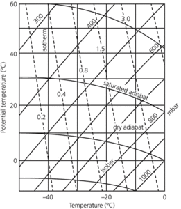
Tephigram: Temperature and humidity are plotted against pressure to illustrate the properties of an entire column of air.
An aerological diagram, of two axes aligned at 45° to each other. The nearly horizontal lines show atmospheric pressure, together with the heights at which they are found; the lines at 45° to the isobars show temperatures, running from bottom left to top right. Superimposed upon these two are three sets of guidelines: those running from bottom right to top left show the dry adiabatic lapse rate (DALR); those running from bottom left to top right, at about 60° to the base, show constant humidity (mixing ratio lines); and convex, curved lines indicate the saturated adiabatic lapse rate (SALR). With the help of these lines, the behaviour of a rising parcel of air may be predicted. First, the readings from a radiosonde are plotted to show the environmental lapse rate. Next, from the same source, dew point temperatures are plotted against height. From the temperature and height of the air parcel under investigation, a plot is made of its temperature fall at the DALR, parallel to the DALR guidelines. Similarly, the dew point change of the air parcel with height is plotted, parallel to the mixing ratio lines. Where these two plots intersect, the parcel will begin to cool at the SALR, and a plot is made of the parcel parallel to the SALR guidelines. At the point where this plot intersects the environmental lapse rate line (above), the height of the top of any cloud formed by the parcel may be established.
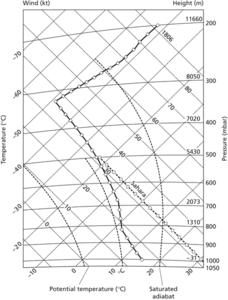
Tephigram
- insecticide
- Insectivora
- insectivore
- insectivorous plant
- insecure host
- inselberg
- insequent drainage
- insert
- insertion
- insertion loss
- insertion reaction
- insertion sequence
- inside money
- insider attack
- insider dealing
- insiders and outsiders
- insider trading
- InSight
- insight learning
- in silico
- insolation
- insolation weathering
- insolubilia
- insoluble
- insolvency